
A trip with friends? Family? Partner? At Hayarkon River Park you will find many lovely corners. Whether you are lovers of history and antiquities, lovers of picnics, or you feel like indulging in a book in a quiet corner, it is a great place to go.
A relaxed urban route
The nature of the trip: a combination of sea, nature, and city in one route – not circular.
Highly recommended for: everyone
Perfect for a picnic: Lunch on the grass in the park or at the Tel Aviv port facing the sea.
Starting point: Hill Square (33 Shimon Hatarsi Street), or in the opposite direction from the Tel Aviv port
When to arrive: noon to sunset
How to get there: It is recommended to get there by public transportation. If you bring your car you can park next to Hill Square in the parking lots.
Track time: about an hour
Track length: about 4 km
The route:
Start in the old north neighborhood of Tel Aviv. It is located in the Hill Square monument named after General John Hill. (The division commander). The address is 33 Shimon Hatarsi Street. Then, pass the Gvirol Bridge, and continue to the Tel Aviv Port. Then, you can walk along the shoreline to the Reading power station. There you will discover the coastal promenade that passes through the famous port lighthouse. This lighthouse is the second history point on the route. There is a mount containing the remains of a fortress that was built to protect the lighthouse too. It is recommended to end the trip at the in Reading Park with the beautiful sunset.
A trip in nature to see the anemones:
Nature of the trip: Beautiful blooms and open space – a circular route
Highly recommended for: everyone
Perfect for a picnic: Anemone Hill, and basically any place in the park
Start and end point: Hod Hasharon Ecological Park
When to arrive: Winter and spring, to see anemones. early in the morning
How to get there: An open public parking lot in Hod Hasharon Park. You can also get there by walking from the direction of Hod Hasharon or by bicycle.
Track time: about two hours
Length: about 6 km
The route:
The route can be started at the spectacular Anemone Hill. Here you will be able to find many different species of the anemones. These are very colorful and beautiful flowers. You can predict that the flowering season will be between December and April. After visiting the hill, continue south – it is possible to go up to Restored Garbage Mountain. This is another great observation point. South of Anemone Hill, about 700 meters away, is Tel Kana, where you will be exposed to the remains of a fortified city at the foot of a larger lower city. In the past, the place was called “Elmormer” and is part of a chain of mounds in the Nahal Hayarkon Reserve.
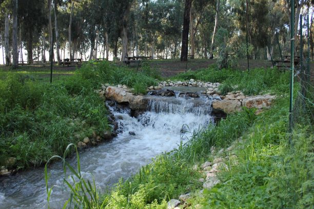
Although no archeological excavations were carried out at this site, from its survey it can be deduced that there was a settlement sequence from the Canaanite days to the days of the Return to Zion. East of Tel Kana, about 500 meters away, you can see the green basins, a system of pools for water treatment and their return to the Hayarkon River Park. The system includes the use of aquatic vegetation typical of the river and natural swamps. It was built by the Yarkon River Authority, as part of the planning of the ecological park. From the green basins you can finish the route back in the ecological park,
Discover the Hayarkon River National Park
Nature of the trip: National park – circular route
Highly recommended for: everyone
Perfect for a picnic: Near the paddling pools, the Nofarim pool, near the spring spring in the national park
Start and end point: Mekorot National Park parking lot
When to arrive: Morning – afternoon (pay attention to closing hours depending on the season)
How to get there: There is a paid parking lot in Mekorot Hayarkon National Park
Track time: about two hours without breaks
Track length: about 6 km
The route:
Start the route in the Mekorot Hayarkon National Park, where the central part of the river flows. Around the river, you will see a lot of vegetation and animals. In this trail you will find the El Mir Mill, the earliest flour mill in the Yarkon that operated until the end of the 19th century. It is named after the local Arab village. The translation is “crossing”, probably because its walls functioned as a bridge to cross the creek. In the south of the national park you can not miss the large pillbox. This was used to guard the railway between Rosh HaAyin and Petah Tikva during the Arab uprising in 1936. In addition, you can reach the charming Nofarim Pool, a reminder of the natural spring area. From there you can return and finish the route back at Mekorot Hayarkon National Park.
It is recommended to have a map of the hiking trails of the Yarkon River Authority when going on these trips.